If you take a look into the history of Bharat, the profound understanding of space and time is just incredible and undisputable. The knowledge about the computation of space and time that emanated from Bharat is truly unbelievable.
Table of Contents
- Understanding the Prime Meridian
- Global Space-Time Calculations
- The Significance of Lanka
- Defining the Days of the Week
- Panchabhuta Stalam: The Five Temples
- Conclusion: A Brief Outlook
- FAQs
Understanding the Prime Meridian
The south pole is referred to as Raksha Salaya and the north pole is referred to as Devata Laya. The line that runs from Rakshasalaya to Devatalaya, which is from South to North, passes through two important cities: Avanti, which is Ujjain, and Rohitaka, which is today’s Rakthak. This line essentially defines the prime meridian, which is the basis for the computation of time in a day.
But what’s crucial to look behind this concept is the origins of latitudes and longitudes. The concept of mapping the entire globe with those imaginary lines we use today for our GPS dates back to Surya Siddhantam or perhaps even before that. Let me be clear: I’m not saying that GPS was invented back then. All I’m asserting is that the antiquity of this scientific concept is far older than we could possibly imagine, and this reflects the profound understanding of Bharatiya civilization regarding space and time.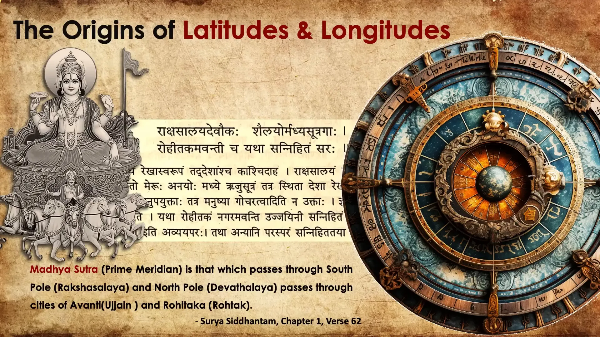
Global Space-Time Calculations
Once the vertically running prime meridian from the North Pole to the South Pole is defined, global space-time calculations also emanated from Bharat. For example, consider this slokam: when the sun rises in Lanka, it sets in Siddhapura, which is like evening in Siddhapura. It’s afternoon in Yamakoti and midnight in Romaka.
This statement illustrates one of the oldest day and night cycles precisely defined in Bharat by Varaha Mehera around 495 AD, which is about fifteen hundred years ago. To be precise, this comes from the thirteenth slokam of the fifteenth chapter of Pancha Siddhantika. This is just one example among many that demonstrate the profound understanding of space and time in Bharat.
Names of Places and Their Significance
What’s particularly interesting here are the names of the places mentioned. For instance, the Australia and New Zealand region is called Yamakoti, the Mexican region or the southern part of the USA is referred to as Siddhapura, and Rome is called Romaka. This nomenclature is significant because it reflects the extensive trade relationships that existed between Rome and Bharat at the time.
Just to put this in perspective, Varaha Mehera precisely defined global positioning and time, and a thousand years later, people were still struggling to navigate to Bharat for its rich knowledge and wealth.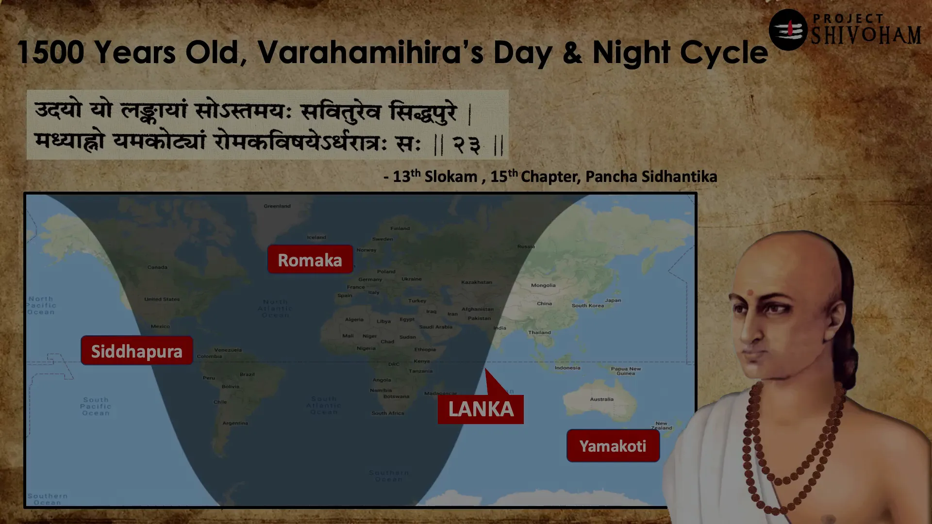
The Significance of Lanka
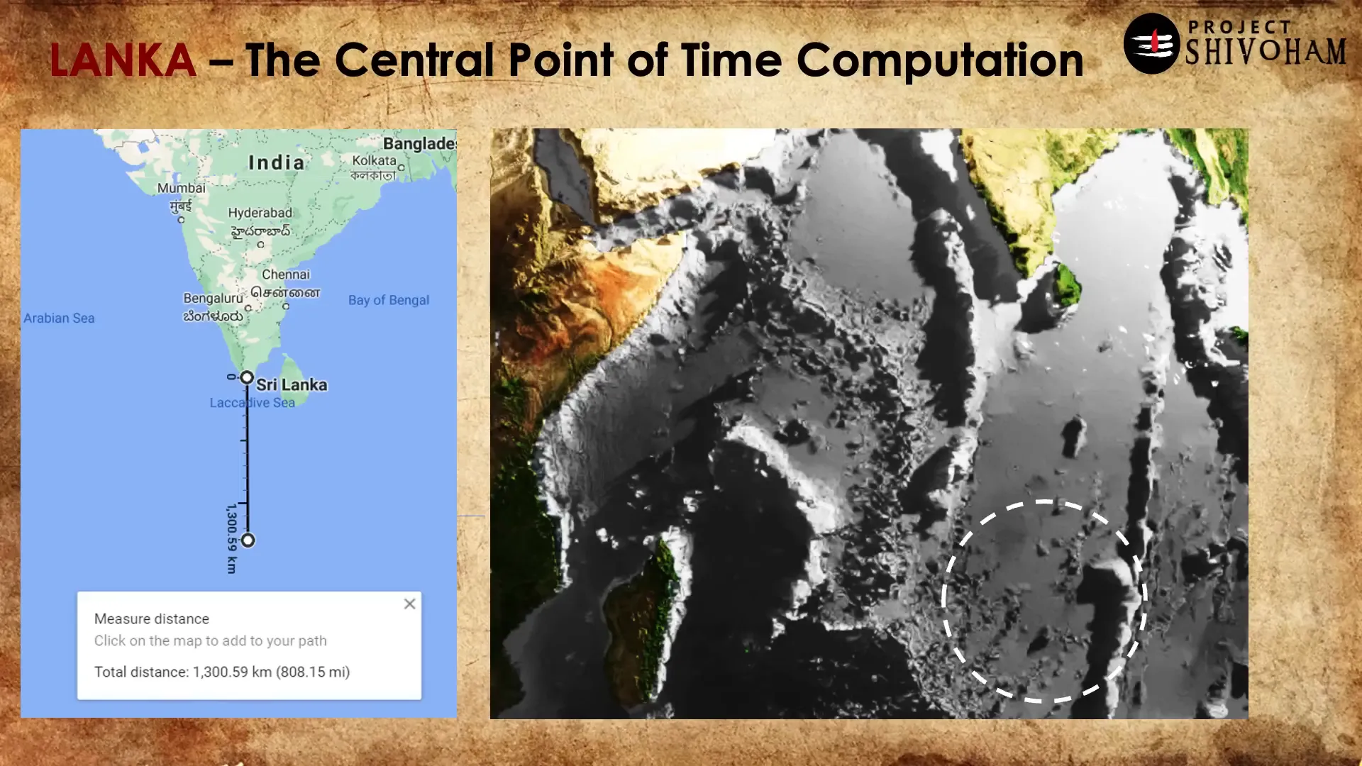
Speaking of space-time, there’s one very important point on Earth that we all should be aware of: that is Lanka. Now, this is not Sri Lanka or Ravana Lanka; rather, Lanka by definition means a land surrounded by water. It lies somewhere in the south of Bharat on the equator. If you remove all the water from the ocean, this is how the ocean floor would look like, and the rough location of Lanka is somewhere around this dotted line because that’s where the equator passes through horizontally.
This Lanka serves as a central reference point for calculating space and time in Bharat. Why is this place significant? It’s simple: this location is an intersection point of the prime meridian and the equator.
Defining the Days of the Week
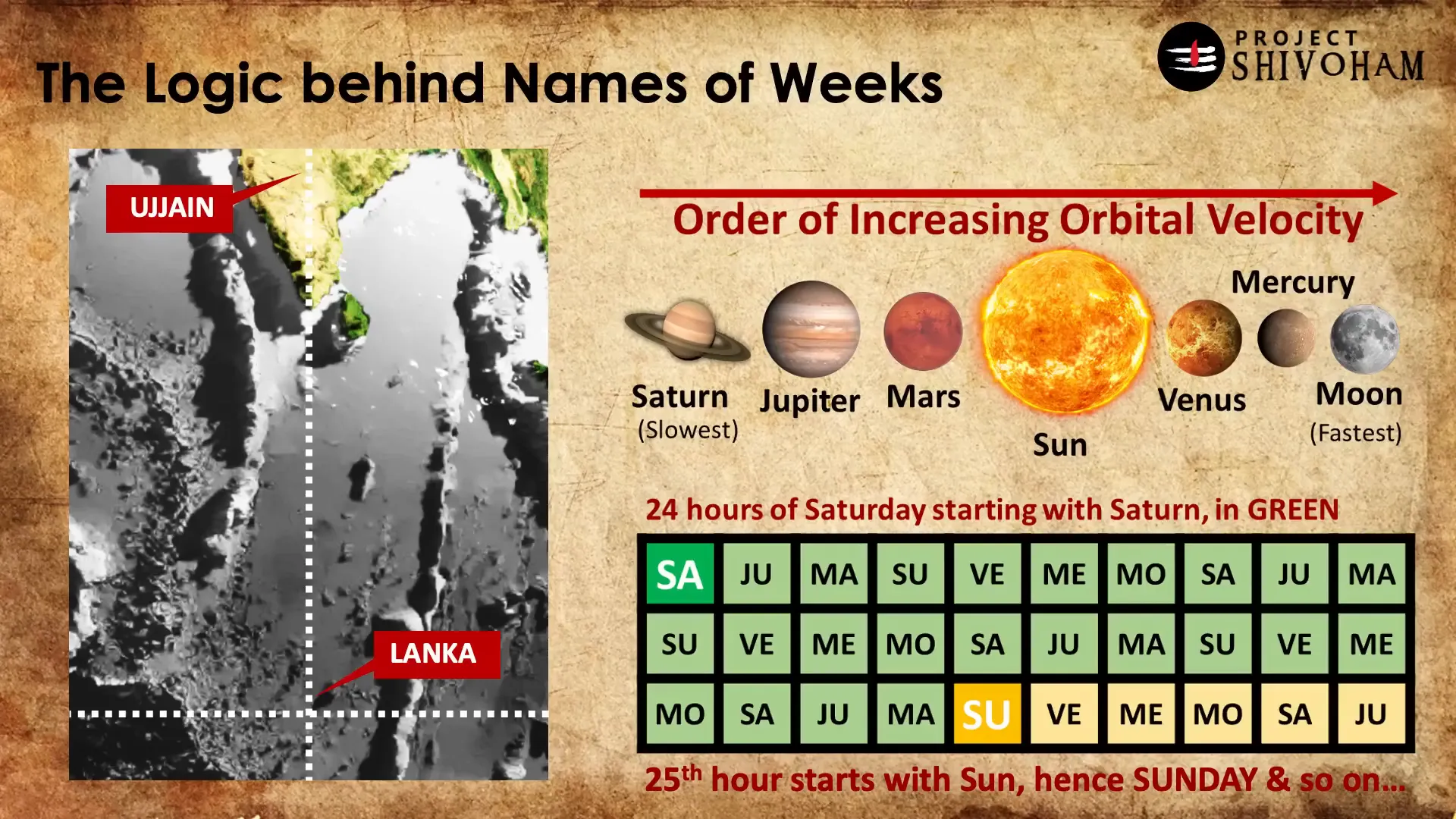
Another example of ancient knowledge about space and time in Bharat is the definition of the days of the week. The planets are sorted in the order of increasing orbital velocity: Saturn is the slowest, and the moon is the fastest. This classification leads to the sequence: Saturn, Jupiter, Mars, Sun, Venus, Mercury, and Moon.
These seven planets, or grahas, are sorted based on their orbital velocities. As I mentioned in an earlier article, one full day or one full Earth rotation is divided into twenty-four parts. This twenty-four-part cycle starts with the sunrise in Lanka. At that point in time, whichever graha is in line with the sun marks the start of that day, and all the planets repeat for each hour period.
The Hora and Muhurta Systems
The twenty-four hora system, which divides one full Earth rotation into twenty-four periods of sixty minutes each, is called a hora. There’s another method of dividing the day into thirty periods of forty-eight minutes each, known as muhurta. The world today uses the hora system for hours, and the word “hour” originates from the Sanskrit word “hora”.
Both systems are correct ways to divide a day, but their purposes differ. The hora is more commonly used for daily activities, while muhurta is reserved for auspicious occasions. It’s also important to note what Brahma Muhurtam is: a period of forty-eight minutes that starts ninety-six minutes before sunrise. This is another example that illustrates our understanding of space and time.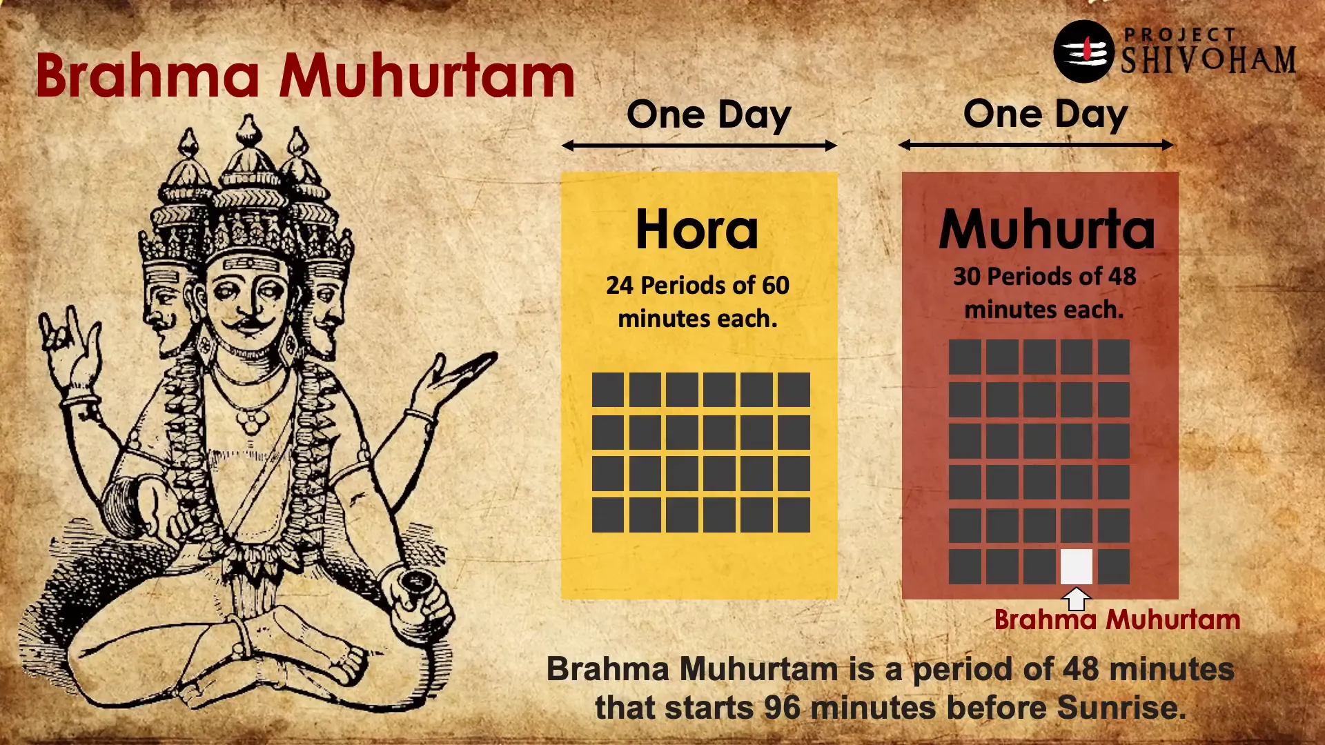
Panchabhuta Stalam: The Five Temples
In the southern part of Bharat, there are five temples of Mahadev: Shri Jambukeswara, Kalahasti Swara, Arunachaleswara, Ekambareswara, and Chidambareswara. All these temples are located in Tamil Nadu and Andhra Pradesh and are revered as Panchabhuta Stalam. Each temple represents one of the five elements: Jambokeswara for water, Kalahastheshwara for air, Arunachaleswara for fire, Ekamveswara for earth, and Chidambareswara for space.
Interestingly, all these five holy shrines are located on the seventy-nine degrees longitude. While it sounds amusing that the temples are spread hundreds of kilometers apart, they are still vertically aligned with the longitude to a decent degree. Ujjain Mahakaleshwar is revered as the god of time and death, and it stands in the same line as Lanka. Hence, Ujjain serves as a reference point.
Whenever Brahma Muhurtam starts in Ujjain, it peaks at all five places of Panchabhuta Stalam. This observation highlights how Ujjain has been the central point of time computation in Bharat for thousands of years.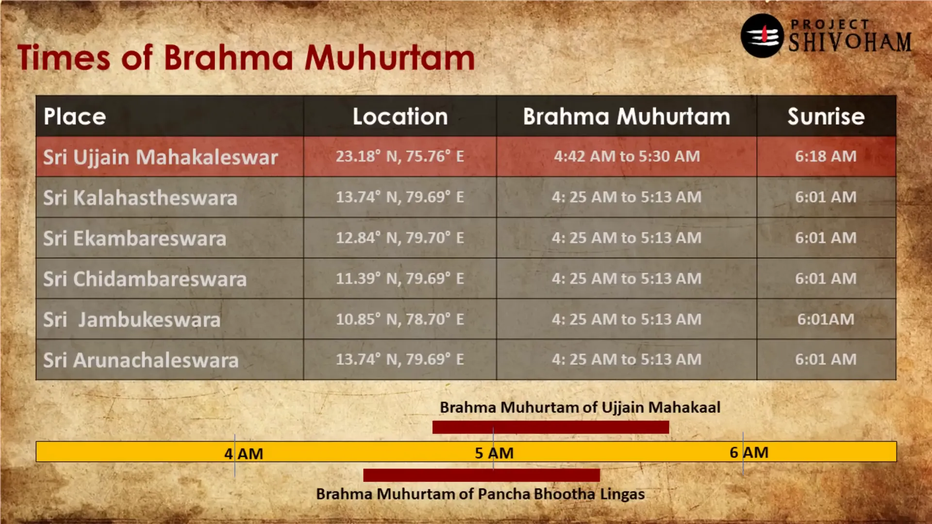
Conclusion: A Brief Outlook
In summary, this is a brief outlook on the ancient knowledge of Bharat regarding space and time. The prime meridian of Bharat once passed through Ujjain, and it still does. However, during colonial times, the British altered the prime meridian to pass through Greenwich, which ignored significant elements like the obliquity of the Earth.
That aspect is taken care of in the Bharatiya Madhyareka passing through Ujjain and Lanka but is not considered in the current prime meridian. This is a deep discussion that merits further exploration.
In future discussions, we will delve into the concept of Jambudvipam, a mythological yet real place that also ties into these ancient understandings. For now, this is all about the ancient knowledge of Bharat in space and time. Thank you for reading!
FAQs
What is the significance of Ujjain in ancient Bharat?
Ujjain is revered as a central point for time computation and is historically linked to the prime meridian of Bharat.
How did ancient Bharat define latitudes and longitudes?
The concept of latitudes and longitudes dates back to ancient texts like Surya Siddhantam, showcasing the advanced understanding of space and time.
What does Brahma Muhurtam signify?
Brahma Muhurtam is a period of forty-eight minutes that starts ninety-six minutes before sunrise and is significant for various auspicious activities.
Where is Lanka located according to ancient texts?
Lanka, in ancient texts, refers to a land surrounded by water, located near the equator, serving as a reference point for calculating space and time.
What are the Panchabhuta Stalam temples?
The Panchabhuta Stalam temples represent the five elements: water, air, fire, earth, and space, and are spread across Tamil Nadu and Andhra Pradesh.
This article was created from the video The Ancient Knowledge on SPACE and TIME – Project SHIVOHAM with the help of AI. Thanks to Aravind Markandeya, Project Shivoham.