Journey with me as we delve into the ancient geography of Jambu Dweep, a mystical landmass that encompasses parts of Asia, Europe, and Africa. Through the lenses of ancient scriptures and historical accounts, we will uncover the rich tapestry of Bharat’s geographical heritage, revealing both mythical and factual elements that have shaped our understanding of the world.
Table of Contents
- The Enigma of Troy
- Varaha Mehta’s Insights on Geography
- Tabula Putingariana: Roman Trade Routes
- Understanding Ancient Indian Geography
- The Concept of Jambudvipa
- The Nine Regions of Jambudvipa
- Bharatavarsha: The Land of Humans
- The Mythical and Geographic Interplay
- Insights from the Vishnu Purana
- The Seven Mountain Ranges of Bharatavarsha
- Major Rivers of Bharatavarsha
- The Role of Sri Ramayana in Geography
- Sugriva’s Directional Search for Sita
- The Critical Analysis of Ancient Texts
- The Mystery of Muziris
- The Legacy of ‘Pattanam’ in Trade
- Understanding Geographical Representation
- The Importance of Critical Thinking
- FAQ: Understanding Jambudvipa
The Enigma of Troy
The city of Troy, a name that reverberates through time, has intrigued historians and archaeologists alike. For centuries, it was debated whether this city existed or was merely a figment of Homer’s imagination. The discovery of its ruins in modern-day Turkiye confirmed its existence, blending history with mythology. Troy stands as a testament to the enduring power of storytelling, reminding us that legends often have roots in reality.
Just like Troy, there are many locations in ancient texts that are shrouded in mystery. Each of these places holds the potential to uncover secrets of our past, waiting for scholars to decode their significance. The journey to understand these enigmatic realms is as compelling as the legends themselves, urging us to explore further.
Varaha Mehta’s Insights on Geography
Varaha Mehta, a luminary in ancient Indian mathematics and astronomy, made significant contributions to our understanding of geography. His work, Pancha Siddhantika, contains profound observations about the day and night cycle across various regions. He articulated that when the sun rises in Lanka, it is evening in Siddhapura, afternoon in Yamakoti, and midnight in Romaka. These references are not just scientific; they offer a glimpse into how ancient civilizations perceived their world.
His geographical insights are monumental. For instance, Lanka, as described by Varaha Mehta, is not merely Sri Lanka but represents a crucial point in ancient geography—the zero-degree meridian of Bharat. This understanding of geography reflects a sophisticated grasp of the world that was far ahead of its time.
Varaha Mehta’s work serves as a bridge connecting the ancient world to our present, illustrating that knowledge of geography transcends time, influencing how we understand our place in the universe today.
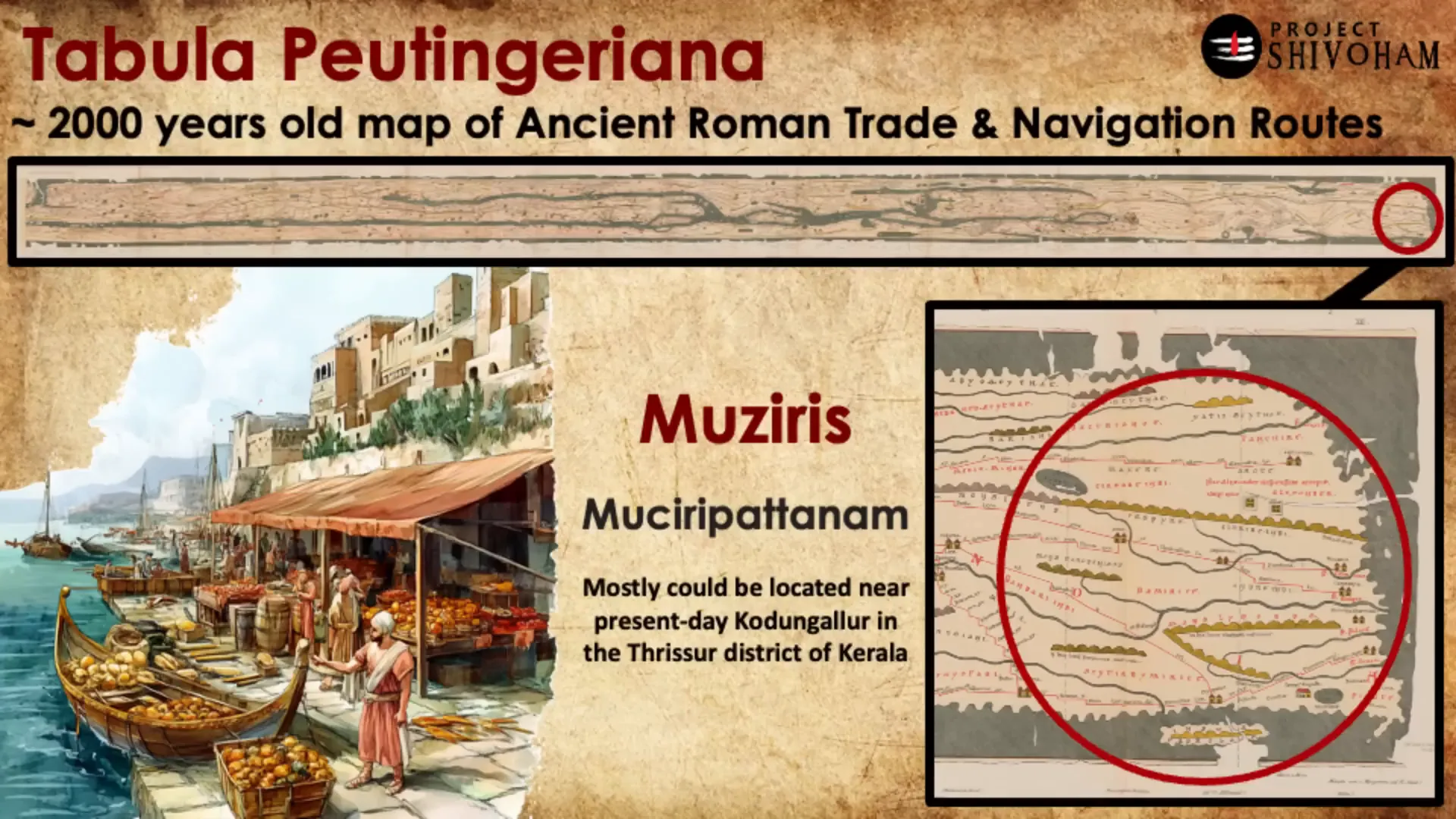
Tabula Putingariana: Roman Trade Routes
The Tabula Putingariana is a remarkable manuscript detailing the trade routes of the Roman Empire, showcasing their extensive connections across the known world. This ancient map serves as a remarkable artifact, illustrating how the Romans navigated and traded with distant lands. One notable location on this map is Muziris, believed to be near present-day Kerala.
The significance of Muziris lies not just in its geographical location, but in its historical role as a bustling port for trade between India and the Roman Empire. The meticulous record-keeping of the Romans highlights their understanding of geography and commerce, which was critical for their economic prosperity.
As we delve into the routes depicted in the Tabula Putingariana, we see a world interconnected through trade, culture, and knowledge. This underscores the importance of geographical documentation in understanding historical narratives and the complex web of interactions that shaped ancient societies.
Understanding Ancient Indian Geography
In Bharat, ancient texts provide a comprehensive understanding of geography that encompasses both physical and metaphysical realms. The concept of sankalpam, a ritualistic invocation of time and space, reveals the intricate relationship between geography and spirituality in ancient Indian thought.
One of the key terms that emerge is Jambudvipa, an enigmatic landmass that symbolizes more than just geography; it represents a worldview that integrates various regions, cultures, and mythologies. Jambudvipa is described in numerous ancient scriptures, each offering layers of interpretation that enrich our understanding of this concept.
Exploring Jambudvipa requires not only geographical insight but also an appreciation for the cultural narratives that inform its interpretation. This dynamic interplay between geography and mythology invites us to reconsider how we perceive ancient texts and their relevance to our understanding of the world.
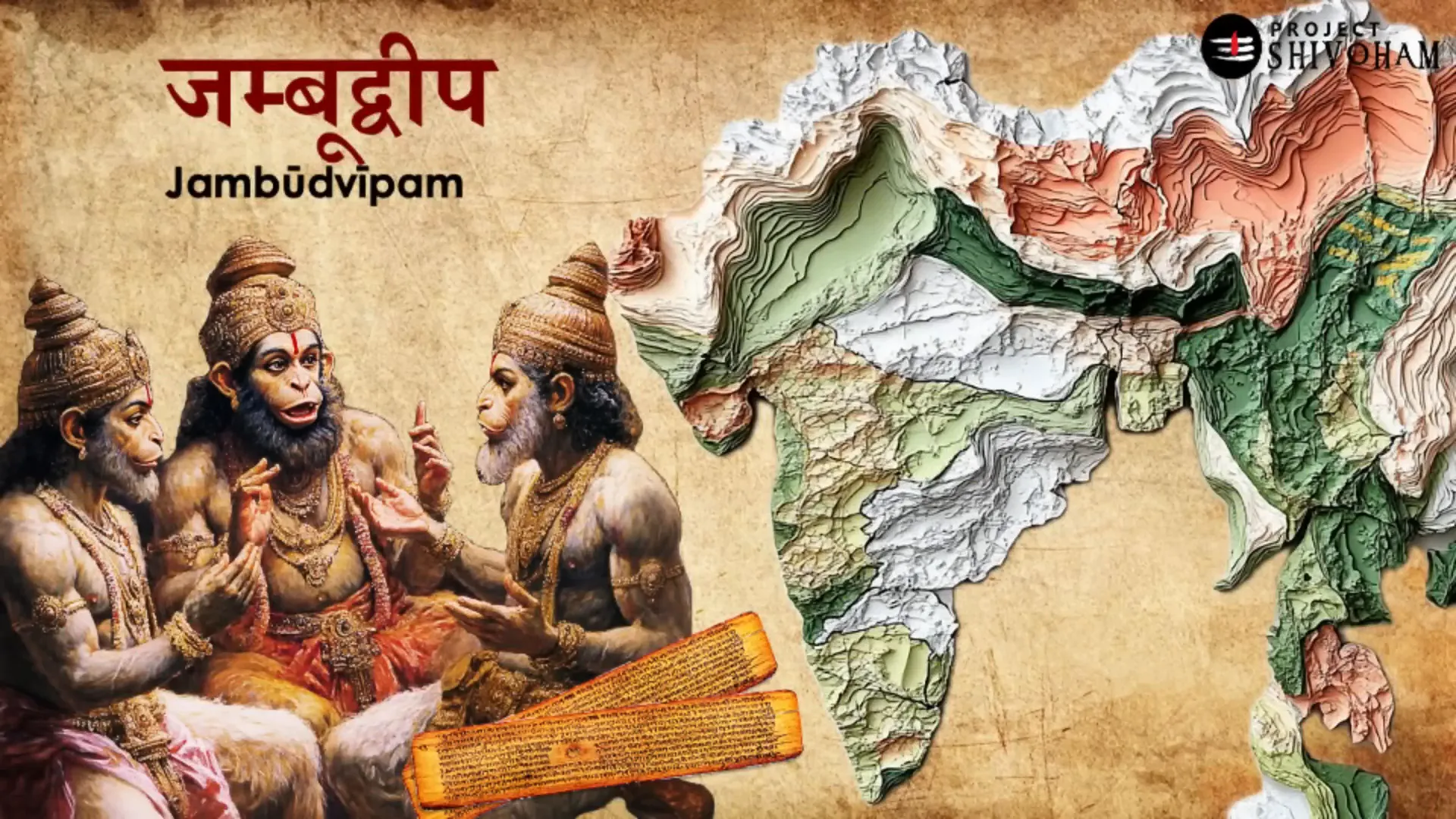
The Concept of Jambudvipa
Jambudvipa, often described as a vast and mysterious land, occupies a prominent place in ancient Indian literature. It is depicted as a landmass encompassing parts of Asia, Europe, and Africa, suggesting a grand vision of the world. This notion of Jambudvipa transcends mere geography; it embodies the spiritual and cultural ethos of ancient Bharat.
In various scriptures, Jambudvipa is portrayed as a sacred space, rich in biodiversity and cultural significance. It is divided into nine regions, each with its unique characteristics and mythological narratives. The references to Jambudvipa in texts like the Vishnu Puranam and the Mahabharatam highlight its importance in understanding the ancient worldview.
As we explore the dimensions of Jambudvipa, we uncover a tapestry of narratives that reflect the interconnectedness of humanity, geography, and spirituality. This concept challenges us to reconsider our understanding of geography not just as a physical space, but as a realm rich in cultural significance.
The Nine Regions of Jambudvipa
Jambudvipa is divided into nine regions or Vashas, each holding its unique identity and significance. These regions include Bharata Varsha, Kimpurja Varsha, Hari Varsha, Ilabhrta, Ramyaka, Hiranmaya, Uttarakuru, Ketumala, and Badrashva Varsha. Each of these areas is described in detail in ancient texts, blending geographical observations with mythological narratives.
- Bharata Varsha: Located in the southernmost part, it is known as the land of humans where actions lead to liberation.
- Kimpurja Varsha: Situated north of Bharata Varsha, it is associated with semi-divine beings devoted to Lord Vishnu.
- Hari Varsha: Further north, inhabited by those free from material desires, presided over by Lord Drasimha.
- Ilabhrta: Central region of Jambudvipa, approximately corresponding to Western Russia and Eastern Europe.
- Ramyaka Varsha: To the northwest, aligning with western Europe.
- Hiranmaya Varsha: Close to the northern pole, possibly linked to the Scandinavian region.
- Uttarakuru Varsha: Located north of Ilabhrta Varsha.
- Ketumala Varsha: Found in the western part of Jambudvipa.
- Badrashva Varsha: Situated in the eastern part of Jambudvipa.
The descriptions of these regions often intertwine mythological elements with geographical realities, creating a complex narrative that reflects the ancient understanding of the world. The challenge lies in deciphering these texts to extract historical and geographical truths.
Bharatavarsha: The Land of Humans
Bharatavarsha, the land of humans, is central to the understanding of ancient Indian geography. It is often described as the space between the snowy mountains and the ocean, a region rich in cultural heritage and spiritual significance. The Puranas elaborate on its geography, detailing major mountain ranges and rivers that define the landscape.
According to ancient texts, Bharatavarsha is flanked by the Himalayas to the north and the Indian Ocean to the south. The seven mountain ranges mentioned in the scriptures—Mahindra, Sahyadri, Rikshadri, Pariprata, Malaya, Suktimat, and Vindhya—serve as geographical markers that shape the identity of this land.
The rivers flowing through Bharatavarsha, such as Shatadru and Chandrabhaga, further enrich its geographical narrative. These rivers are not merely water bodies; they symbolize the lifeblood of the land, nurturing its inhabitants and sustaining its culture.
Through the lens of ancient texts, Bharatavarsha emerges as a profound representation of humanity’s connection to the land, inviting us to explore our roots and the rich tapestry of history that defines our existence.
The Mythical and Geographic Interplay
The interplay between mythology and geography in ancient texts is a fascinating exploration. In Bharatavarsha, the mythical narratives are intricately woven with geographical realities, creating a rich tapestry of cultural identity. The ancient scriptures do not merely serve as records of geography; they encapsulate a worldview that blends the sacred and the mundane.
For instance, the concept of Jambudvipa is not just a geographical delineation but a symbol of spiritual significance. It invites us to reflect on how ancient civilizations perceived their world, attributing divine attributes to geographical landmarks. This synthesis of myth and geography encourages a deeper understanding of how space and place influenced cultural narratives.
Insights from the Vishnu Purana
The Vishnu Purana offers profound insights into the geography of Bharatavarsha. It describes the land as a sacred space, situated between the snowy mountains and the oceans. This positioning highlights the duality of nature, where the divine and the earthly coexist. The text indicates that Bharatavarsha is a realm where human actions have spiritual ramifications, emphasizing the significance of karma in shaping one’s destiny.
Moreover, the Puranic accounts of the seven mountain ranges and major rivers provide a detailed understanding of the landscape. These geographical features are not just physical entities but are imbued with spiritual meaning. The mountains serve as metaphors for stability and permanence, while rivers symbolize the flow of life and prosperity.
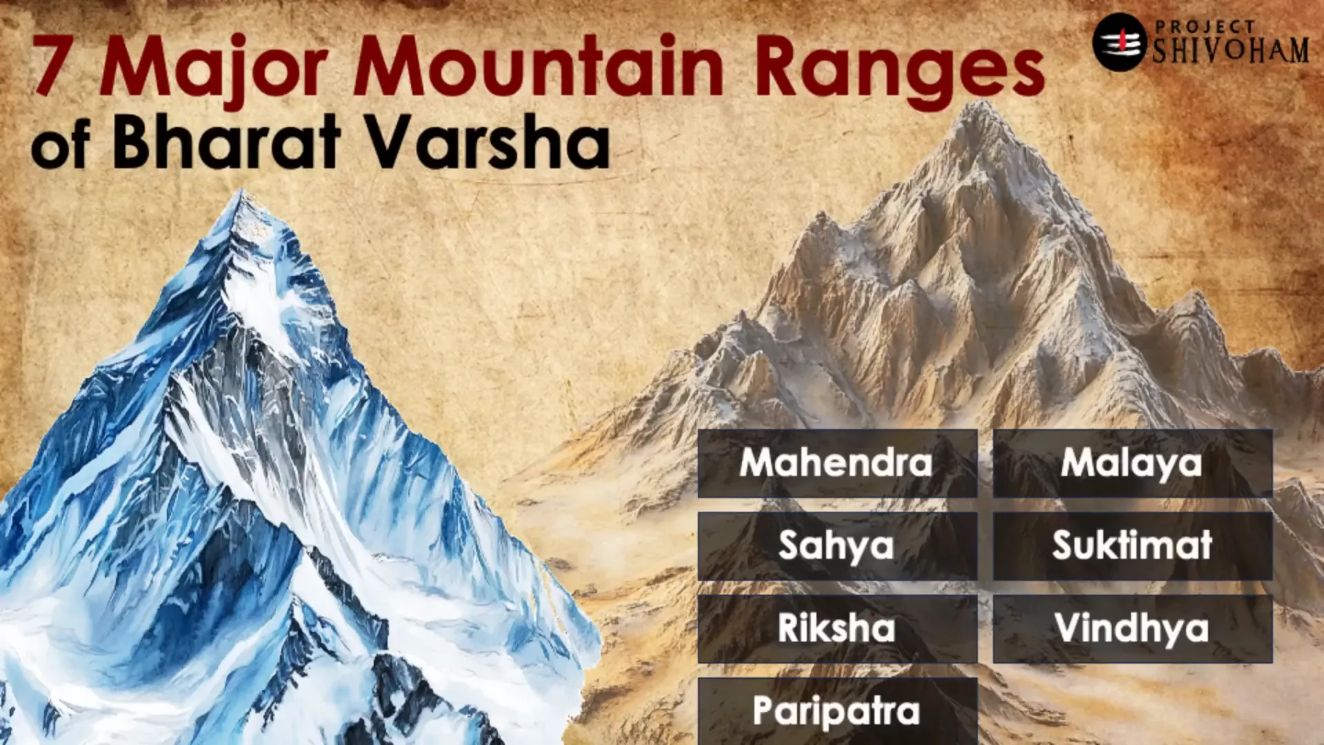
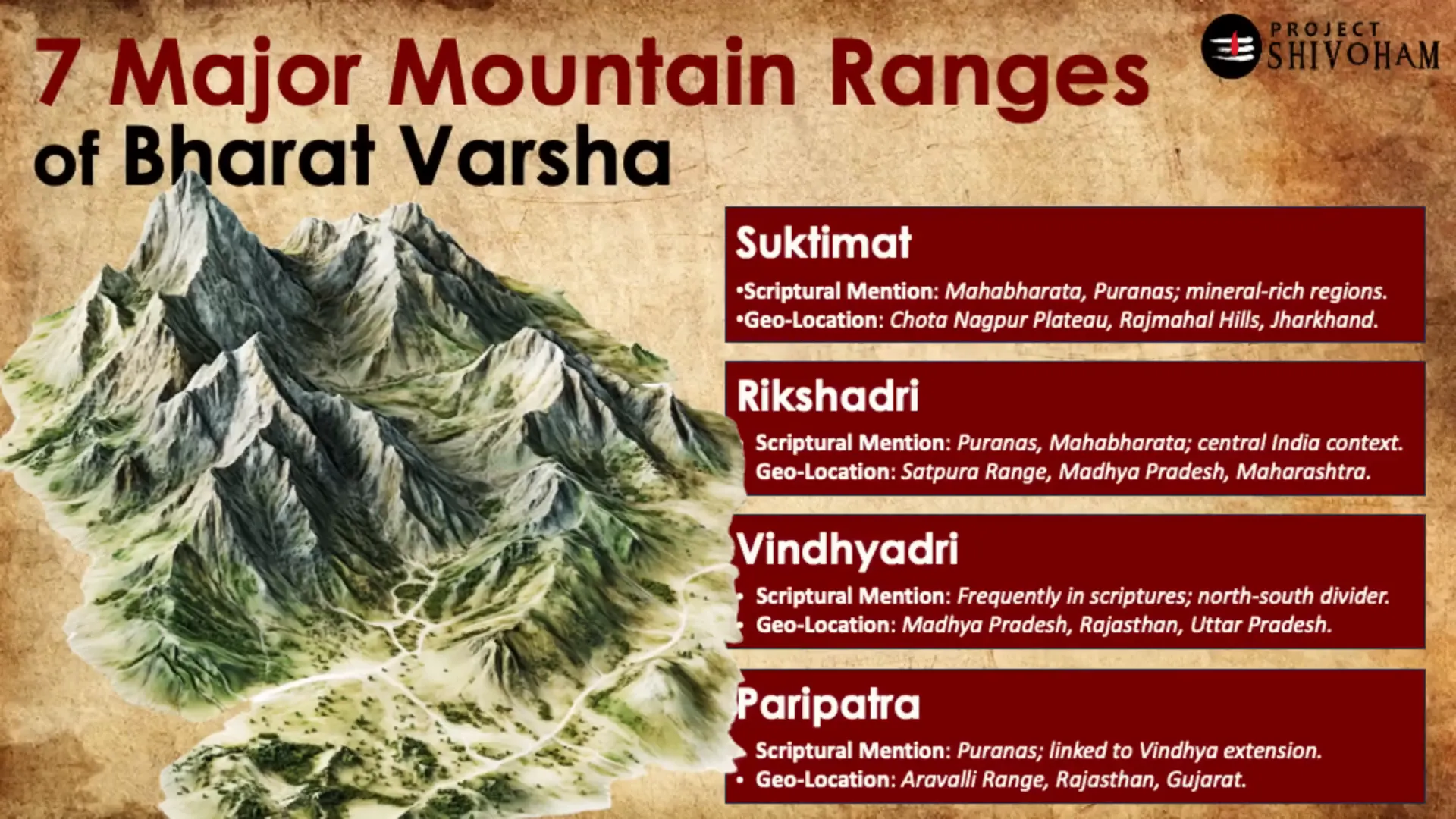
The Seven Mountain Ranges of Bharatavarsha
According to the Puranas, Bharatavarsha is defined by seven major mountain ranges, each with its unique characteristics. These are:
- Mahindra: Linked to the Eastern Ghats, it is described as a significant landmark in ancient texts.
- Sahyadri: Known today as the Western Ghats, it plays a crucial role in the ecology of the region.
- Rikshadri: This range, associated with the Satpura mountains, symbolizes strength and resilience.
- Vindhya: Often depicted as a divider between northern and southern Bharat, it holds historical significance.
- Malaya: Located in the Western Ghats, it is celebrated for its biodiversity and beauty.
- Sukhtimat: Rich in minerals, this range is linked to the Chotanagpur Plateau.
- Paripatra: An extension of the Vindhya range, it emphasizes the interconnectedness of geography.
These mountain ranges are not only geographical markers but also cultural symbols that reflect the identity of Bharatavarsha. They are revered in various scriptures and continue to be significant in contemporary narratives.
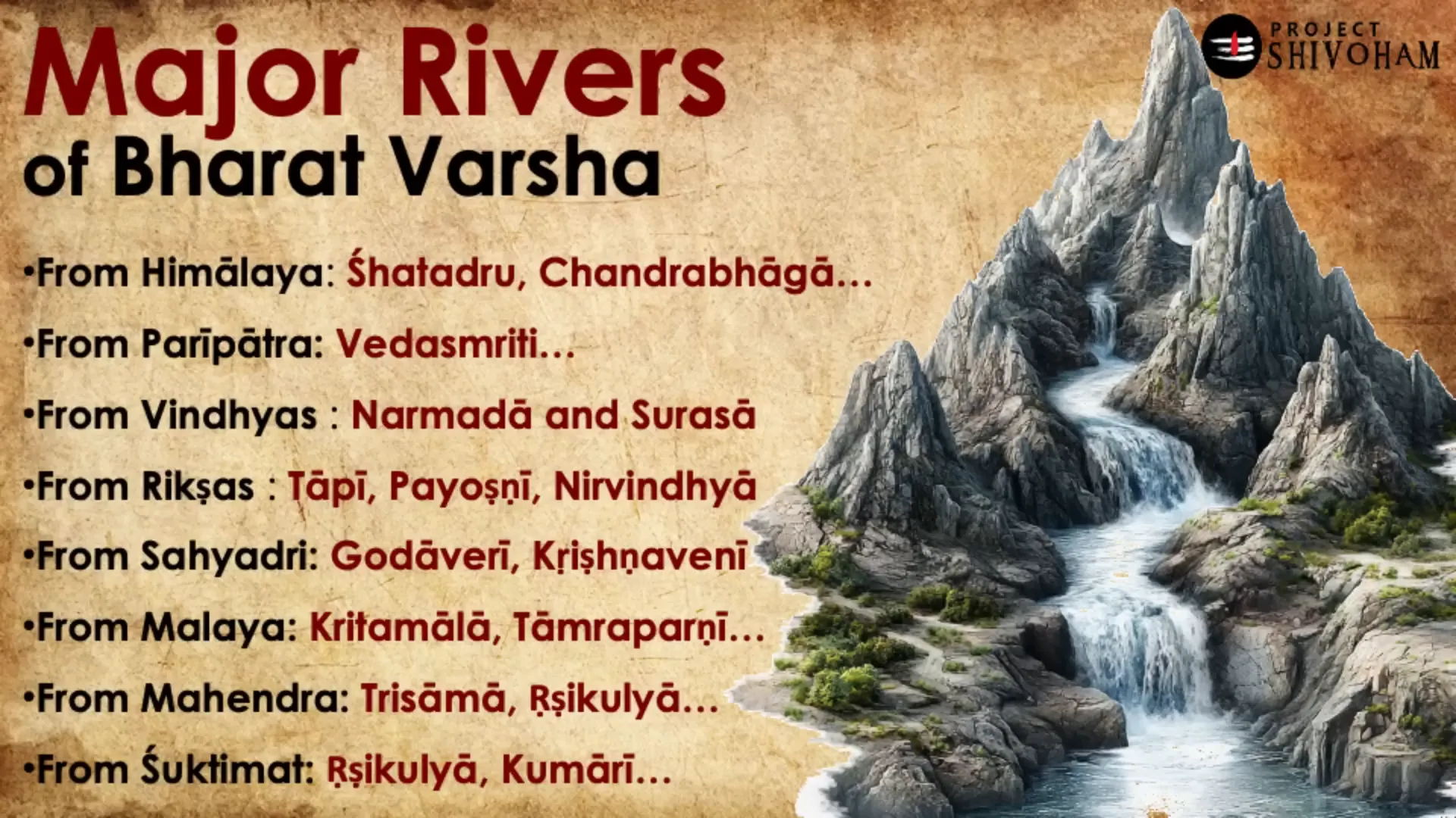
Major Rivers of Bharatavarsha
The rivers of Bharatavarsha are celebrated in ancient texts as vital sources of sustenance and spirituality. The Puranas detail several significant rivers:
- Shatadru: Identified with the Sutlej, this river is described as having a hundred tributaries, symbolizing abundance.
- Chandrabhaga: Known today as the Chenab, it is a river that embodies the lunar essence.
- Narmada: Flowing through the Vindhya range, it is often associated with cleansing and rejuvenation.
- Godavari: Revered as the Ganges of the South, it is a lifeline for many communities.
- Krishna: This river holds immense cultural significance, often linked with various deities.
Each river narrates its own story, reflecting the symbiotic relationship between humans and nature. The names and characteristics of these rivers have evolved, yet their essence remains rooted in the ancient texts.
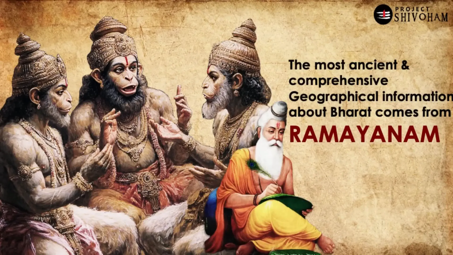
The Role of Sri Ramayana in Geography
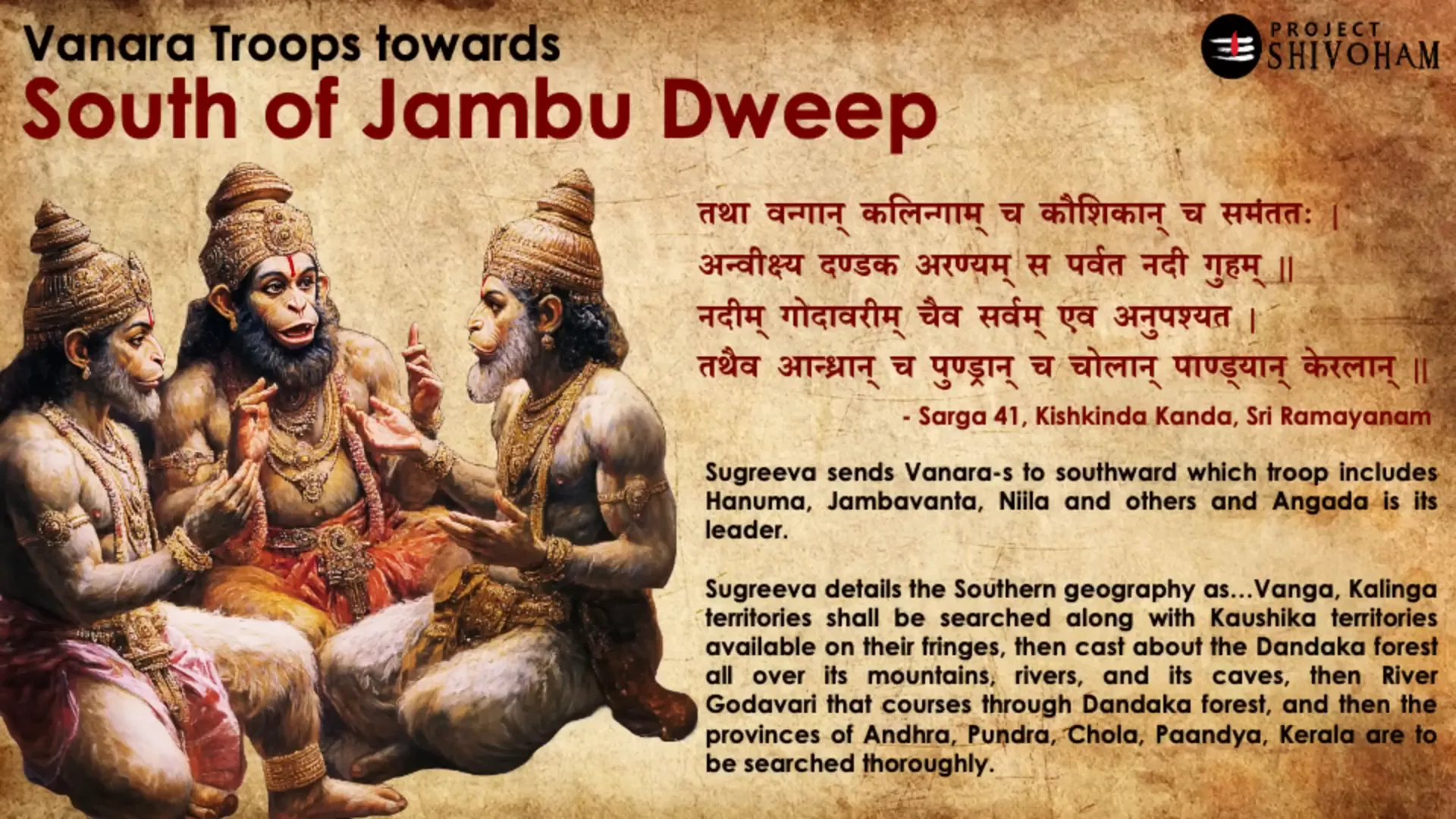
The Sri Ramayana serves as a crucial reference for understanding the geography of Bharatavarsha. When Sugriva orders the search for Sita, he delineates the landscapes and kingdoms across the four cardinal directions. This not only highlights the geographical diversity of ancient Bharat but also showcases the cultural richness embedded within these regions.
Each direction explored by Sugriva is filled with unique rivers, mountains, and kingdoms. For example, the eastern expedition covers prominent rivers like the Yamuna and kingdoms such as Kashi and Kosala. The southern journey traverses through the Dandaka forest and includes regions like Andhra and Kerala, while the western expedition includes Saurashtra and Bahlika.
This geographical narration within the Ramayana provides a comprehensive understanding of the ancient world, emphasizing how geography influenced the narratives of heroism and adventure.
Sugriva’s Directional Search for Sita
Sugriva’s strategic division of the Vanaras into groups to search for Sita illustrates the geographical awareness of ancient Bharat. Each group was sent in a specific direction, covering vast territories. The detailed descriptions of the landscapes they traversed provide insight into the intricate knowledge of geography possessed by ancient Indians.
For instance, the eastern search led by Vinatha covered rivers and kingdoms, while the southern expedition under Angadar explored the Dandaka forest and the provinces of Andhra and Kalinga. This meticulous detailing not only aids in geographical understanding but also enriches the narrative with cultural and historical significance.
The Critical Analysis of Ancient Texts
Engaging with ancient texts requires a critical lens. While they are often viewed as mythological, it is essential to approach them as historical documents that reflect the worldview of ancient civilizations. By analyzing these texts with an open mind, we can uncover valuable insights into the geographical and cultural landscapes of Bharatavarsha.
For example, the identification of Muziris in the context of trade routes illustrates how ancient narratives can inform our understanding of historical geography. The connections between ancient ports and modern locations invite us to reconsider the significance of these texts in mapping our historical heritage.
This critical analysis encourages a dialogue between the past and present, allowing us to derive meaning from ancient narratives while acknowledging their historical contexts.
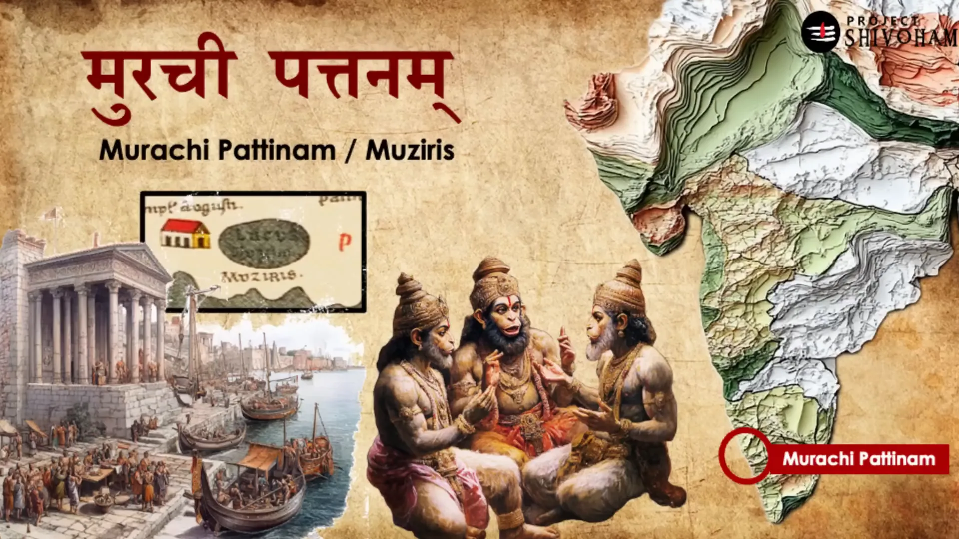
The Mystery of Muziris
The ancient port of Muziris, often romanticized in historical texts, stands at the crossroads of trade and culture, linking Bharat with the Roman Empire. This bustling hub was not just a point of commerce but a melting pot of ideas and traditions. The Romans, with their meticulous record-keeping, documented their trade routes, which included Muziris, highlighting its significance in the global trade network of antiquity.
Archaeological evidence suggests that Muziris thrived as a port city, facilitating the exchange of spices, textiles, and precious stones. This trade was not one-sided; it brought Roman goods to Indian shores, enriching both cultures. The legacy of Muziris is seen as a testament to the interconnectedness of ancient civilizations, underscoring the importance of trade in shaping cultural identities.
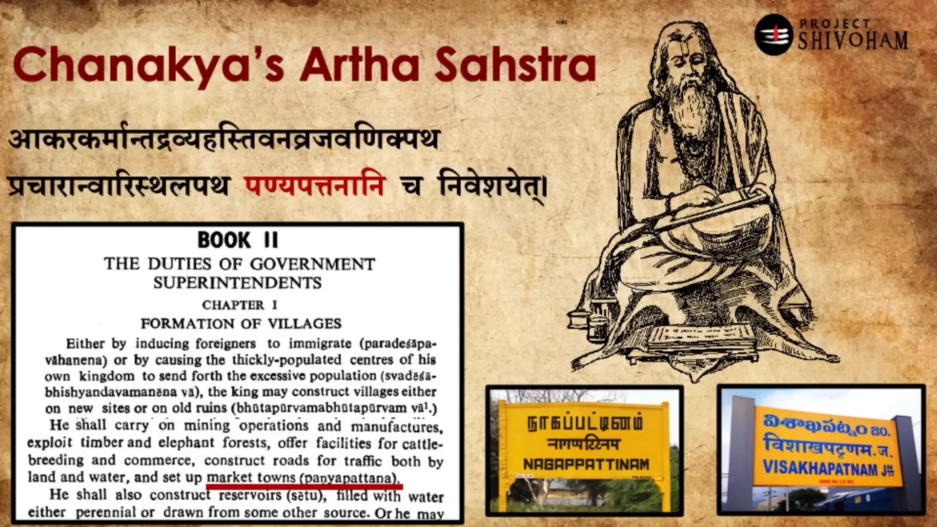
The Legacy of ‘Pattanam’ in Trade
The term ‘Pattanam’ derives from the Sanskrit word ‘patanam,’ meaning a market town. This concept persists in the names of modern port cities such as Nagapattinam and Visakhapatnam. The etymology reflects the enduring influence of ancient trade practices on contemporary geography.
In the context of Muziris, the term ‘Murachi Pattanam’ resonates strongly. This name evokes the bustling activity of ancient marketplaces where traders from various regions converged. The mention of ‘Murachi Pattanam’ in the Ramayana suggests that the area was significant not only for commerce but also for cultural exchanges.
This legacy highlights how trade routes were vital arteries for the flow of goods and ideas, shaping the socio-economic landscape of the time. The continuity of these names into modern usage showcases the lasting impact of these ancient trade hubs on the cultural and linguistic fabric of Bharat.
Understanding Geographical Representation
Geographical representation in ancient texts is a blend of imagination and reality. The Puranas and Itihasas often use poetic language to describe landscapes, making it challenging to pinpoint exact locations today. This artistic representation serves a dual purpose: it evokes a sense of wonder while also grounding the narratives in the known world.
For instance, the description of Bharatavarsha as lying between the ocean and the snowy mountains is both literal and metaphorical. It illustrates not just the physical geography but also the spiritual significance attributed to these landscapes. The Himalayas, revered as the abode of the gods, and the seas, symbolizing life and sustenance, create a rich tapestry of meaning.
Understanding these representations requires critical thinking. We must discern the poetic from the literal, appreciating the cultural context while seeking geographical accuracy. This dual approach enriches our understanding of ancient texts, allowing us to appreciate their depth and complexity.
The Importance of Critical Thinking
Engaging with ancient scriptures demands a critical mindset. It is crucial to approach these texts not merely as myths but as historical documents that provide insights into the geography and culture of their time. For example, the references to Muziris and other locations in the Ramayana should prompt us to investigate their historical context rather than dismiss them as mere fiction.
Critical thinking allows us to navigate the complexities of ancient narratives. By analyzing the geographical references within their cultural contexts, we can uncover the historical truths that lie beneath the layers of mythology. This process not only enhances our understanding of Bharat’s history but also fosters a deeper appreciation for its rich heritage.
As we explore these ancient texts, we should strive to balance reverence for their spiritual significance with a rigorous examination of their historical claims. This nuanced approach is essential for preserving the integrity of our cultural heritage while embracing the lessons of the past.
FAQ: Understanding Jambudvipa
What is Jambudvipa?
Jambudvipa is an ancient term that refers to a mythical landmass described in various Puranas. It symbolizes a vast region encompassing parts of Asia, Europe, and Africa, representing a unique blend of geography and mythology.
How is Jambudvipa divided?
Jambudvipa is divided into nine regions, known as Vashas: Bharata Varsha, Kimpurja Varsha, Hari Varsha, Ilabhrta, Ramyaka, Hiranmaya, Uttarakuru, Ketumala, and Badrashva Varsha. Each region has its distinct characteristics and mythological significance.
What is the significance of Bharata Varsha?
Bharata Varsha is considered the land of humans and is central to the understanding of ancient Indian geography. It is depicted as a region where actions lead to liberation, emphasizing the spiritual and cultural ethos of Bharat.
How do ancient texts inform our understanding of geography?
Ancient texts provide insights into the geographical knowledge of the time, blending mythological narratives with real-world locations. This interplay enriches our understanding of how ancient civilizations perceived their environment and its significance.

This article was created from the video The Ancient Geography of Asia, Europe & Africa – JAMBU DWEEP with the help of AI. Thanks to Aravind Markandeya, Project Shivoham.